

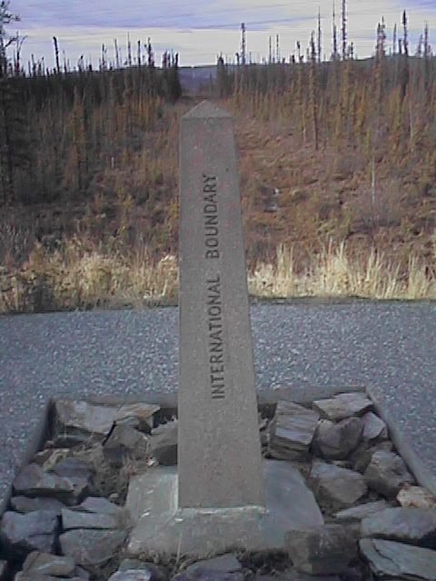
 It was cool but sunny as I bicycled four and a half miles to the border.
I crossed pass the U.S. customs and then I was in Canada! Hooray! Hooray!
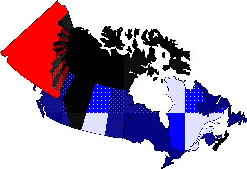
The time changed one hour to Pacific time. I had titled my ride a bicycle
ride across Canada, so it was nice to finally get started. The border itself
was marked with a stone marker and a twenty foot cleared section.
Apparently, the clearing was done almost the entire length of the 141st
meridian.
It was cool but sunny as I bicycled four and a half miles to the border.
I crossed pass the U.S. customs and then I was in Canada! Hooray! Hooray!
The time changed one hour to Pacific time. I had titled my ride a bicycle
ride across Canada, so it was nice to finally get started. The border itself
was marked with a stone marker and a twenty foot cleared section.
Apparently, the clearing was done almost the entire length of the 141st
meridian.
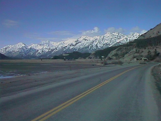
Crossing into Canada, the road revered to chip-seal. It was very wide, although the shoulders were filled with too much gravel to ride well. Hence, I rode towards the middle of the lane. For this next segment and much of the day, the road wound itself up and down small hills. I had left a major river and thus was going from drainage to drainage.
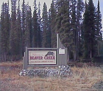 Canadian customs was located 32km from the Border just outside Beaver Creek.
Crossing customs was easy. They wanted to know where I lived, how long in
Canada, if I had any weapons and how much money I had. Apparently, the
Canadian customs will turn back people for having inadequate funds if
they believe they might become stuck on the road. I did ask them for a
stamp in my passport. A souvenir.
Canadian customs was located 32km from the Border just outside Beaver Creek.
Crossing customs was easy. They wanted to know where I lived, how long in
Canada, if I had any weapons and how much money I had. Apparently, the
Canadian customs will turn back people for having inadequate funds if
they believe they might become stuck on the road. I did ask them for a
stamp in my passport. A souvenir.
Beaver Creek was still half closed for the winter. I found the local bank. Banker's hours in Beaver Creek are Tuesdays from 10-Noon and Thursdays from 1-3. I was in luck! I cashed some travelers checks to have some Canadian bills. I also stopped in town for an early lunch.
Outside Beaver Creek, the road became very remote very quickly. It is hard to describe, but on this next stretch, I felt very much aware of the isolation It was all very remote, peaceful and calm. There was very little traffic. It had clouded over and there was an occasional snow flake, but the clouds were high enough to see mountains alongside. I would stop and listen to the wind or to a stream, being very aware of the remoteness. I was alone on the road. I felt very much alone.
Six miles outside Koidern the road turned to gravel. I'd actually been traveling on pretty yucky chip-seal so at first the gravel road was actually smoother and easier travel. However, after a bit, I hit the construction zone where they were wetting down the road. Yuck! Soft mud to get into everything including up in the fenders.
I the road was paved again through Koidern. The first two motels in Koidern
were closed. The next motel would be 27km further (if it was open). Luckily
I was able to find a place at the Koidern River Fishing Lodge. Just beyond
the motel it looked like the gravel road began again. More fun for the next
day!
![]()
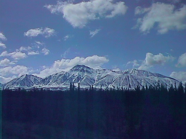
 On the road by 7am and ready to tackle the gravel. I decided to forgo
breakfast and instead catch it at Pine Valley 17 miles hence. The
temperature was 33 degrees and there as an occasional snow flurry. However,
it looked like it was going to get sunnier and warmer. As the sun came out
the white peaks became even more majestic.
On the road by 7am and ready to tackle the gravel. I decided to forgo
breakfast and instead catch it at Pine Valley 17 miles hence. The
temperature was 33 degrees and there as an occasional snow flurry. However,
it looked like it was going to get sunnier and warmer. As the sun came out
the white peaks became even more majestic.
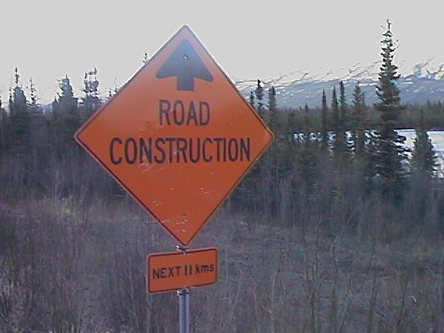 Initially the gravel took some more friction, and I tried cycling in the
smoothest part of the lane. About five miles down, I encountered the real
road construction sign. Shortly thereafter, a flagger stopped me, "be
careful, lots of large trucks". They were reconstructing about a mile of
road. I both cycled and walked my way past half a dozen different
construction vehicles.
Initially the gravel took some more friction, and I tried cycling in the
smoothest part of the lane. About five miles down, I encountered the real
road construction sign. Shortly thereafter, a flagger stopped me, "be
careful, lots of large trucks". They were reconstructing about a mile of
road. I both cycled and walked my way past half a dozen different
construction vehicles.
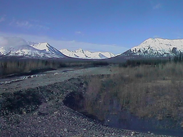
After the construction was past and I was again cycling on gravel. Many large gravel loading trucks passed on the road. The route paralleled the Kluane Range of mountains, a dramatic line of 7000ft peaks. As the clouds lifted, I was very much aware of both the beauty and isolation of the range. When there weren't gravel trucks, it was all very beautiful and peaceful.
 Pine Valley motel/cafe was at mile 17. Cafe closed. Oops, so much for
breakfast. Out came the crackers and peanut butter as well as a few
fruit bars. A lady came out to tell me they'd be opening next week.
She was kind enough to fill my water bottles though.
Pine Valley motel/cafe was at mile 17. Cafe closed. Oops, so much for
breakfast. Out came the crackers and peanut butter as well as a few
fruit bars. A lady came out to tell me they'd be opening next week.
She was kind enough to fill my water bottles though.
Soft loose gravel after Pine Valley. About six miles out was another construction zone. In this one they were spreading loose gravel paste and then wetting it down. This paste crept up into the wheels and stuck to the fenders. This slowed things down dramatically and I was walking for a good distance.
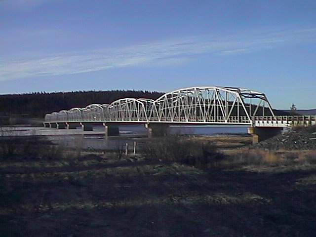
Kilometer 1822 was the Donjek bridge and an end to the gravel. Hooray! Some 50kms (30 miles) and I was tired of this stuff. Unfortunately, the combination of a light headwind, missing breakfast and a climb out was taking its toll. I was pretty slow climbing several kms out from the valley.
I reached the top of the hill and was able to zoom much faster to Kluane
Wilderness Lodge at km 1797. I ordered enough that the cook asked if it
was for one or two. I was hungry. Briefly listened to voicemail and then
set off towards Burwash Landing.
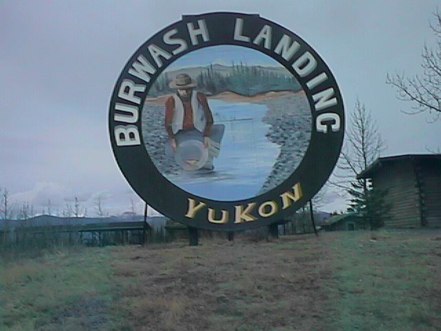 Headwind was more constant, so the mileage went by slowly. Luckily, the
scenery was still awesome. Around 4pm I dropped in on Burwash Landing.
Had a pleasant conversation with the lodge manager before cycling another
ten miles to Destruction Bay to end the day. It was about time as snow
flurries were again coming down.
Headwind was more constant, so the mileage went by slowly. Luckily, the
scenery was still awesome. Around 4pm I dropped in on Burwash Landing.
Had a pleasant conversation with the lodge manager before cycling another
ten miles to Destruction Bay to end the day. It was about time as snow
flurries were again coming down.
![]()
 Nice easy day today. Wonderful sunny weather all day long. A little chilly
with only a slight headwind in parts of the trip, but I'm getting more used
to that. Left Destruction Bay shortly before 8am. This time with breakfast.
This was good, since I didn't find a single place open until I was close to
Haines Junction.
Nice easy day today. Wonderful sunny weather all day long. A little chilly
with only a slight headwind in parts of the trip, but I'm getting more used
to that. Left Destruction Bay shortly before 8am. This time with breakfast.
This was good, since I didn't find a single place open until I was close to
Haines Junction.
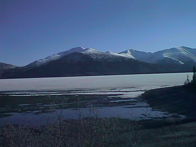
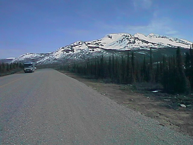
 The route took me along the shores of Kluane Lake. The lake was still frozen
but occasional inlets were thawed and showed open water. Alongside the lake
was a range of ~7000ft mountains. It was peaceful and relaxing.
The route took me along the shores of Kluane Lake. The lake was still frozen
but occasional inlets were thawed and showed open water. Alongside the lake
was a range of ~7000ft mountains. It was peaceful and relaxing.
I passed by Soldier's Summit, the point at which crews working from the east and the west had first connected the road in 1942. Kluane Lake had been a large obstacle in building the highway. Sharp cliffs needed to be blasted and a wide meandering river needed to be bridged. Prior to the Alaska Highway, a wagon road had existed from Whitehorse to the south part of the lake, with people getting further access by boat.
 Silver Creek was km 1698. From the point, the road climbed up out of
the Kluane Basin. I made it to Boutillier Summit at 1003 meters. Stopped
there for a lunch of crackers and peanut butter. The road wound a bit, but
still paralleled some dramatic mountain ranges.
Silver Creek was km 1698. From the point, the road climbed up out of
the Kluane Basin. I made it to Boutillier Summit at 1003 meters. Stopped
there for a lunch of crackers and peanut butter. The road wound a bit, but
still paralleled some dramatic mountain ranges.
Bear Creek Summit, 1004 meters, was at Kilometerpost 1656. From here the road descended some ten kilometers to the "outskirts" of Haines Junction. Made it in by 2:30pm on a pretty relaxing ride. A slight concern was that I noticed my rear wheel out of true. I tightened some spokes, took care of the immediate issue.
In Haines Junction I had a choice of motels! I picked one with direct
dial phones, so was able to update the web for the first time.
![]()
 I felt like the general theme for today was, "going to Whitehorse".
Whitehorse is a town of 20,000 people and there was little else on today's
route. Had a 7am breakfast in the cafe and then took off. A few practice
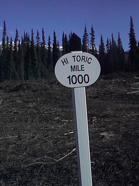
hills going out of town. The route was well marked with mileage markers.
Normally the route is marked with kilometer posts every two miles. In
addition the route is periodically marked with "historical mile" markers.
These are the original mileposts and are actually 32 miles longer than the
were in Kilometers. Signs to nearby businesses were half in miles and half
in kilometers. When asking for directions, I almost always was told
distances in miles.
I felt like the general theme for today was, "going to Whitehorse".
Whitehorse is a town of 20,000 people and there was little else on today's
route. Had a 7am breakfast in the cafe and then took off. A few practice
hills going out of town. The route was well marked with mileage markers.
Normally the route is marked with kilometer posts every two miles. In
addition the route is periodically marked with "historical mile" markers.
These are the original mileposts and are actually 32 miles longer than the
were in Kilometers. Signs to nearby businesses were half in miles and half
in kilometers. When asking for directions, I almost always was told
distances in miles.
What a difference wind direction can make! Today I had both some headwinds and tailwinds. For a while in the afternoon, I was drifting along with a 20mph tailwind. Bicycle was in highest gear and it was easy to cycle along. At the end of the day coming into Whitehorse, I had the reverse, a 20mph headwind. I slowly fought and slogged my way into town.
Stopped briefly at the Otter Falls cutoff store at 20 miles and then
continued another 20 miles to Champagne.
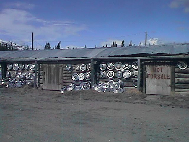 Champagne was a small community that had seen better times. There were
some nice display signs and also a large hubcap collection. I had an
early lunch of cheese, crackers and a chocolate bar.
Champagne was a small community that had seen better times. There were
some nice display signs and also a large hubcap collection. I had an
early lunch of cheese, crackers and a chocolate bar.
After Champagne I climbed a hill and had some wonderful tailwinds. I was
easily zooming along. The miles passed by quickly.
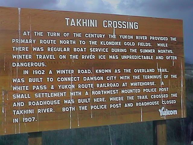 The winds shifted slowly and started coming more from the south. First
a crosswind and then headwinds. I stopped at historical mile 937. This
marked a crossing of the Takhini river by an old stage road. Whitehorse
had gotten its name from "Whitehorse Rapids", along the Yukon River. The
rapids required a portage around them. Whitehorse was originally a staging
area for Dawson City and the Klondike gold rush. It had since grown to be
the largest city in the Yukon.
The winds shifted slowly and started coming more from the south. First
a crosswind and then headwinds. I stopped at historical mile 937. This
marked a crossing of the Takhini river by an old stage road. Whitehorse
had gotten its name from "Whitehorse Rapids", along the Yukon River. The
rapids required a portage around them. Whitehorse was originally a staging
area for Dawson City and the Klondike gold rush. It had since grown to be
the largest city in the Yukon.
Shortly after Takhini, I started seeing signs for Whitehorse. City limits were actually 10miles out. The headwinds increased and those last ten miles took an eternity to slog out. I arrived by 5pm and was pretty worn out.
Whitehorse was a big town. Lots of traffic. No bicycling signs on the
main street. It felt awkward again to be in the big city. I found a motel
downtown and briefly wandered around. Couldn't wait to get out on the
road again.
![]()
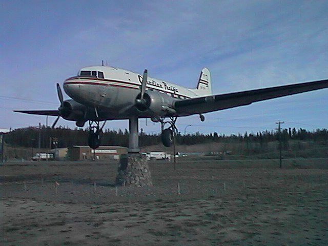 Headwinds all day long today. Particularly strong at Marsh Lake, but also
reasonably strong starting out. A few miles hence, I passed by the airport.
The Whitehorse airport has the world's largest weathervane: an old DC-3
mounted on a pedestal. It was pointed to the south, the direction I was
traveling.
Headwinds all day long today. Particularly strong at Marsh Lake, but also
reasonably strong starting out. A few miles hence, I passed by the airport.
The Whitehorse airport has the world's largest weathervane: an old DC-3
mounted on a pedestal. It was pointed to the south, the direction I was
traveling.
I was still fresh, so I just put things into a lower gear and fought my way upwind. A little over ten miles out of town, the road forks, with a side road to Skagway. I stopped briefly for coffeecake and a coke. Six miles further, the road crossed the Yukon River at the Marsh Lake Dam. The dam had been constructed in 1924 to help moderate flows past Whitehorse. Marsh Lake it created had also become a popular destination for Whitehorse residents. There weren't too many today, since the lake was still frozen.
The wind picked up across the flat expanse of Marsh Lake and was gusting
pretty strong. My speed slowed even more. Slowly the miles slogged by.
 There is something even more obnoxious about wind than hills. At least
with a hill, you know you're building up energy to release on the downhill.
Choice of accommodations on this stretch were few. Campgrounds were still
officially closed, although I'm sure I could have camped almost anywhere.
Otherwise, the choices were Jake's Corner at mile 52 and Teslin at mile 110.
Though it was only 2pm, I decided to stop early for the day at Jake's
Corner.
There is something even more obnoxious about wind than hills. At least
with a hill, you know you're building up energy to release on the downhill.
Choice of accommodations on this stretch were few. Campgrounds were still
officially closed, although I'm sure I could have camped almost anywhere.
Otherwise, the choices were Jake's Corner at mile 52 and Teslin at mile 110.
Though it was only 2pm, I decided to stop early for the day at Jake's
Corner.
![]()
I made reasonable time in the first thirty miles, reaching Johnson's Crossing at 9:30am. Campgrounds I passed and Johnson's Crossing itself were all still closed. Locals tell me that this is true until the last week of May or so. It was peaceful and calm to cycle along with very little traffic in this stretch. I had left the bustle of Whitehorse behind.
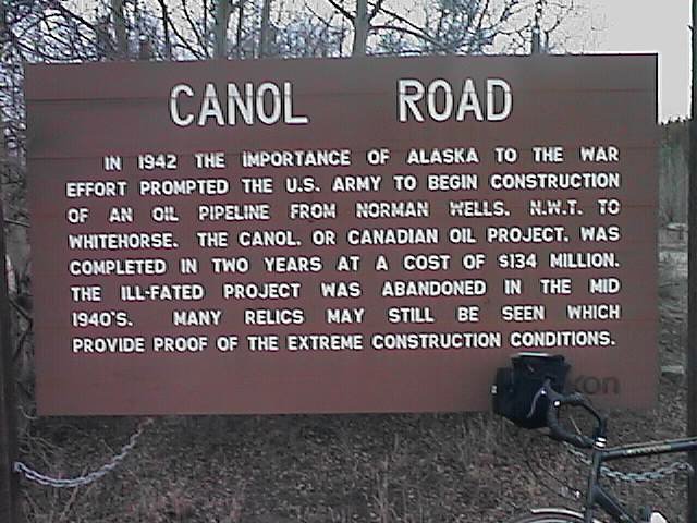 At Johnson's Crossing was a turnoff for the Canol Road. "Canol" is an
abbreviation for "Canada Oil". During the second world war, in 1942 a
road was built from this point to Norman Wells some 500+ miles away. Along
this road, a 4 inch pipeline was placed to pump oil from Norman Wells to
a refinery at Whitehorse. This was during the era when Japan had invaded
the Aleutian Islands and there was some scare about availability of oil.
At Johnson's Crossing was a turnoff for the Canol Road. "Canol" is an
abbreviation for "Canada Oil". During the second world war, in 1942 a
road was built from this point to Norman Wells some 500+ miles away. Along
this road, a 4 inch pipeline was placed to pump oil from Norman Wells to
a refinery at Whitehorse. This was during the era when Japan had invaded
the Aleutian Islands and there was some scare about availability of oil.
The gravel road and pipeline was built with a lot of effort to overcome great adversity in terrain and climate. It cost $134 million which resulted in oil at approximately 4x the going rate. The pipeline itself was abandoned in 1944 after the greatest scare was over. The first 472km of the highway to the NWT border are still maintained in the summer as a gravel road. The remaining road in the NWT has been abandoned. Hiking the abandoned road seems like an ultimate wilderness adventure to try sometime.
After Johnson's Crossing I headed upwind. The wind picked up across the still-frozen Teslin Lake was strong. The road itself had gentile climbs and descents as it went along the lake. Luckily, many of the climbs were protected from the wind, so I mostly had light winds on the climbs. I did have to pedal down most of the descents to overcome the wind. Breakfast had been crackers and peanut butter, so I was starting to get hungry.
I stopped at Mukluk Annies outside Teslin. This establishment was still
closed, but did allow me to ask about lodges along the way. Halsteads
five miles further was closed. Morley River in 39 miles might closed but
he really wasn't certain. As I cycled in to Teslin, it started to rain
lightly. This helped clinch the decision, stay in Teslin rather than push
another 27 miles to a lodge that might be closed. It was still early, but
I would hope for more forgiving weather the next day.
![]()
 Beautiful morning! The storm front blew through the previous evening with
gusty wind, some rain and rapidly moving clouds. This morning the skies
were clear, sunny and winds were calm. I carefully cycled across the steel
deck of the Nisultin bridge. The bridge was followed by a steep hill that
set some of the tone for the day: gently rolling terrain with occasional
sharp hills.
Beautiful morning! The storm front blew through the previous evening with
gusty wind, some rain and rapidly moving clouds. This morning the skies
were clear, sunny and winds were calm. I carefully cycled across the steel
deck of the Nisultin bridge. The bridge was followed by a steep hill that
set some of the tone for the day: gently rolling terrain with occasional
sharp hills.
It felt great to be cycling along in clear skies and NO WIND! Yeah! Mileage went much quicker than the day before. Shortly after 9am, I dropped in at the Morley River Lodge, some 40kms away. Picked up some road info (caution, more construction ahead) and two snickers bars. Immediately after Morley River, the road crossed the British Columbia Border. The next 70kms would be in BC. However, the route still felt like Yukon and even had "Keep Yukon Clean" road signs. The 'official' crossing would be later.
Saw a moose wallowing in a stream. Also noticed for the first time that many
trees and bushes had buds and some even had leaves starting. Spring!
Beautiful sunshine continued and it continued to be calm. The route
paralleled the Swift River.
 Off in the distance, the Cassiar Mountains marked the continental divide.
These mountains were not as high as the rockies I would cross later, but did
mark the drainage divide between Yukon and MacKenzie Rivers.
Off in the distance, the Cassiar Mountains marked the continental divide.
These mountains were not as high as the rockies I would cross later, but did
mark the drainage divide between Yukon and MacKenzie Rivers.
Stopped in for a meal at Swift River Lodge. These Canadians really do
say "eh" at the end of sentences.
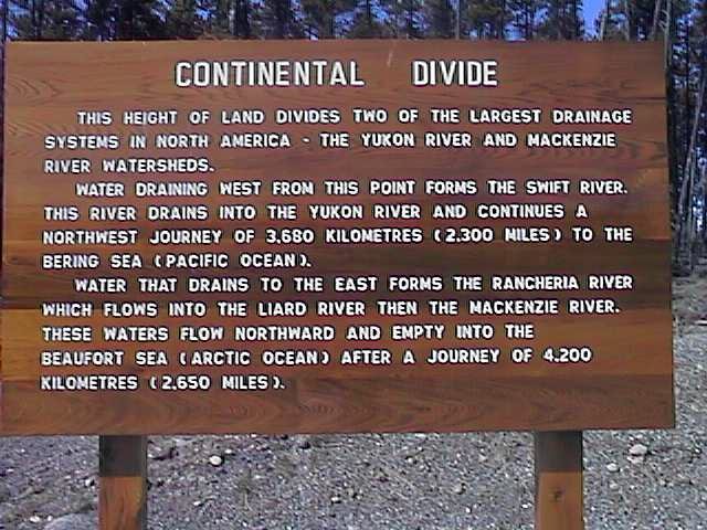 After lunch, climbed the last distance to the Continental Divide. The
road had several sharp hills and even some descents. The actual final
hill up to the divide was pretty tame. It actually continued briefly
past the signs and then went down to the Rancheria River.
After lunch, climbed the last distance to the Continental Divide. The
road had several sharp hills and even some descents. The actual final
hill up to the divide was pretty tame. It actually continued briefly
past the signs and then went down to the Rancheria River.
About a mile past the divide was "Walker's Continental Divide". Today
was their opening day. Two young clerks from Alberta were getting things
set up. After Walker's, the road mostly descended down to Rancheria where
I stayed for the evening.
![]()
 After following the river for 40km, the route crossed the river and
entered a region of rolling hills covered with lodgepole pine. At km 1290
there was a stretch of road construction for 24kms. Sigh. There was a
bit of everything on the road: hard-packed gravel, soft gravel, wet pasty
gravel, etc. Among the most obnoxious were cars/trucks zooming past
kicking up dust. "Slow down!", I'd say, to no avail.
After following the river for 40km, the route crossed the river and
entered a region of rolling hills covered with lodgepole pine. At km 1290
there was a stretch of road construction for 24kms. Sigh. There was a
bit of everything on the road: hard-packed gravel, soft gravel, wet pasty
gravel, etc. Among the most obnoxious were cars/trucks zooming past
kicking up dust. "Slow down!", I'd say, to no avail.
After construction, the route had more hills than I imagined. Struggle to go up, only to zoom down the other side. This section also had many messages spelled out in stones. Most were names, but there was also a "peace on earth!", a bicycle and a smiley face.
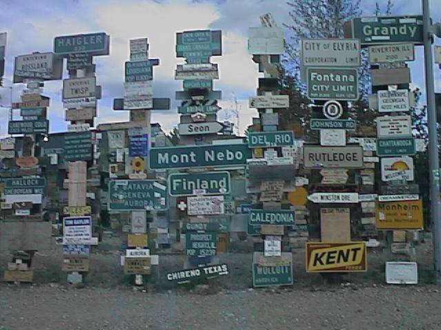
 Lunch at Junction 37, then several more hills up and down in the last
22kms to Watson Lake. One last hill and then I was at the Signpost
forest. This collection of 20,000 signs from all over the world was
started in the 1940s. There were far too many to look at them all, but
I had fun finding familiar places.
Lunch at Junction 37, then several more hills up and down in the last
22kms to Watson Lake. One last hill and then I was at the Signpost
forest. This collection of 20,000 signs from all over the world was
started in the 1940s. There were far too many to look at them all, but
I had fun finding familiar places.
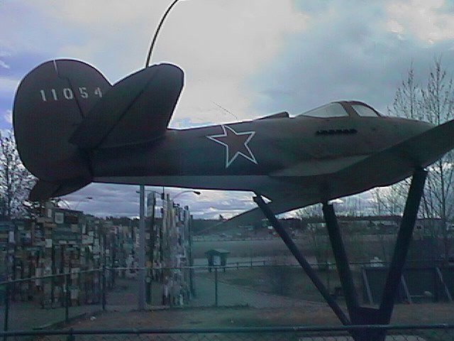
Also at the visitor center was a mockup of a P-39 fighter with Russian markings. Along the Alaska Highway were a sequence of airports known as the Northwest Staging Route. The airports (Fort Nelson, Watson Lake, Whitehorse, Northway, Fairbanks) were used to ferry some 8000 lend-lease airplanes to Fairbanks. Here they were given to the Russians and flown further to Nome, across Siberia to the European front. Among the reasons for the routing of the Alaska Highway were to go along with the northwest staging route.